Download Tower Steward Handbook
Tower Steward Handbook
TABLE OF CONTENTS
This booklet is intended to be a guide for you, the volunteer tower steward/ interpreter. Hopefully it will help you when interacting with visitors on the mountain. It contains some basic information on the effort to save the tower from removal, the formation of the Friends of St. Regis Mountain Fire Tower group and the restoration project. It also provides information on the forest preserve, the history of the fire tower, the jobs of the rangers and observers, outdoor ethics, and other recreational activities in the surrounding area. You are not expected to know all the material; rather it is hoped that this guide will give you confidence to relate with visitors in a friendly and informative manner. Your responsibility, as an interpreter is to educate the public. Review this as needed and feel free to refer to it when on the mountain.
The NYSDEC restricts the number of people on the tower to 6 because of the narrow stairs and the small cab size.
Take initiative in greeting tower visitors. Consider wearing a Friends hat or patch when volunteering on the mountain.
Explain your presence and offer to answer questions.
Attempt to answer questions in a friendly manner.
Remember that for some, this may be the first mountain climbed and the first tower visited.
Encourage hikers to stay on well-established paths to protect fragile vegetation.
Politely discourage any signs of vandalism, in particular graffiti, to the tower or summit. The interpreter has no authority to enforce regulations; common sense and friendly persuasion are your only tools. Should illegal activities be observed and persist, they should be reported to the forest ranger dispatch center: 518-897-1300.
With the first sound of thunder (near or far), or the sight of an approaching storm, immediately exit the tower and the mountain summit. Encourage others to do the same.
In case of a medical emergency, notify ranger dispatch 518-897-1303 or 518-891- 0235 (Search and Rescue).
If a helicopter is sent to the mountain, have one person stay with the subject to protect them from flying debris and remove everyone else from the summit, including all items (packs, clothing, etc.) that may blow up into the rotor blades.
St. Regis Mountain Facts
Located in the northern section of the Adirondack Forest Preserve, Town of Santa Clara, Franklin County, New York.
St. Regis Mt. is located in the St. Regis Canoe Area, an 18,400-acre area managed as wilderness. Visit this link for more information:
http://www.dec.ny.gov/lands/70572.html
In 1918, the present 35-foot Aermotor galvanized steel fire tower was erected by the NYS Conservation Commission. (Tower is measured from the ground to the floor of the cab.)
When the tower was erected, the mountain and much of the surrounding land was owned by William Rockefeller.
Near the fire tower there are three markers imbedded in the rock. These markers were placed by the U.S. Coast & Geodetic Survey (USCGS) in 1942. The marker with the triangle stamped in the center is often referred to as a bench mark, but in this case it is actually a Triangulation Station; the other markers are Reference Marks that were placed to help locate the station and to reestablish it if necessary. The 1942 placement of these markers is likely significant as World War Two was in progress and there was an effort to create a rigid framework for accurate mapping which would strengthen the defense of the Nation in case there was a need for military activities.
The tower was staffed by a fire observer until 1990, making it one of the last staffed towers in New York State.
In the 1990s, the tower was slated to be removed by the DEC due to being deemed a “non-conforming structure” in the St. Regis Canoe Area.
After years of effort by the Friends of St. Regis Mountain Fire Tower group, the APA approved a 1/2 acre parcel surrounding the tower, designating it as a historic site, thus removing its non-conforming status and preventing it from being removed. In 2015 the restoration of the fire tower began.
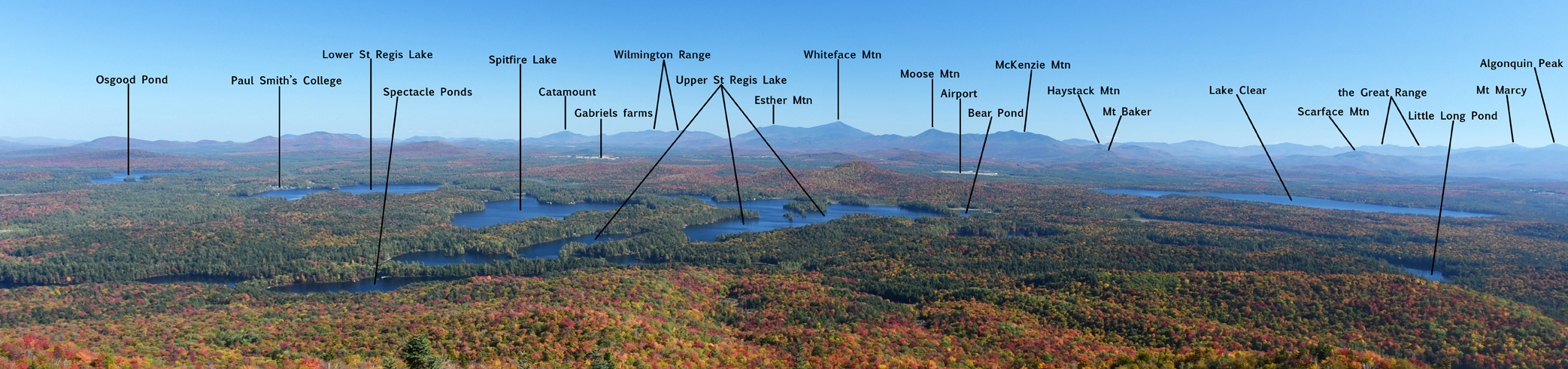
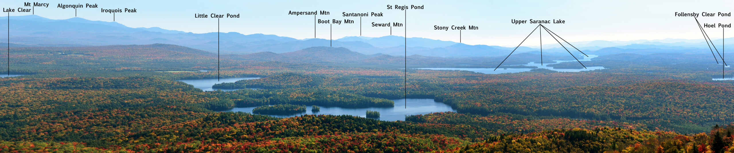
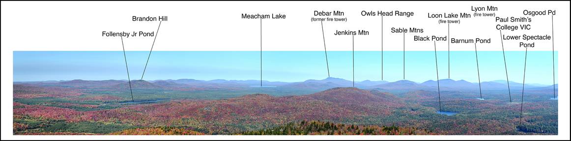
It has been estimated that a half million acres can be seen from the tower including the St. Regis Canoe Area, Upper Saranac Lake, Lake Clear, other ponds and lakes, many of the high peaks including Whiteface Mountain, as well as parts of the Canadian border to the north.
St. Regis Mountain elevation is 2874 feet and the trail from Keese Mill Rd is 6.8 mile round trip. The trail from Upper St. Regis Lake is 4.6 miles round trip.
Devastating fires in 1903 and 1908 destroyed over 464,180 and 368,000 acres of land in the Adirondack Mountains respectively — that is over 13% of today’s park. In April 1910, an observer was stationed on St. Regis Mountain. Because of fires atop the mountain (and associated erosion), no tower was needed. During this first year of use, three miles of telephone line were constructed so that the observer could quickly report fires spotted to the local forest ranger. There is no evidence that a tower was ever built on St. Regis until 1918, when the Conservation Commission erected a 35 ft. Aermotor LS40 steel tower that still remains there today.
First Tower Observer
George F. Brown was assigned as the first observer on St. Regis Mountain. In his first year he reported 55 fires, of which a few were dangerous. On the afternoon of May 31, 1915, a small fire, which was probably left by fishermen in the town of Santa Clara, was fanned by swift winds. The fire destroyed 1,550 acres of state land, most of which had been burned from a previous fire.
By 1916 each observation station included a cabin for the comfort of the observer. Previously, most were provided only tents for shelter. These original cabins were usually constructed of logs cut on site. Most were small and less than ideal. In the early 1920’s a standard cabin design would be developed.
Tower Technology
In 1919, a device known as the “Osborne Fire Finder” was developed by the US Forest Service. By means of this type of alidade (a mapping instrument used for determining directions), a panoramic map of the territory visible from a mountain station could be developed. This made it possible for an inexperienced observer to locate fires more accurately than with ordinary topographic maps. One of the new fire finders was purchased and tried out at Poke-O-Moonshine during the year, along with a map made according to the Conservation Commission.
A panoramic map and table were installed on St. Regis in that same year to aid the observer in locating fires. This was a circular map with a panoramic sketch of the surrounding vista around the outside edge. The inner portion was a topographic map with the tower location in the center. A sighting device called an “alidade” pivoted on a pin in the center of the map. Along the outer edge of the topographic map portion are azimuths that could be easily read by the observer once the alidade was sited on a possible fire. This location was then reported to the local forest ranger.
During the 1930s the Conservation Department began to experiment with two-way radios to improve communications between its fire towers and forest rangers
The Cabin
The first standard design for observer cabins was developed in 1922, mandating that they be 12 ft. x 16 ft. in size and roofed and sided with asphalt shingles. These consisted of a small living area, and even smaller bedroom and a pantry. A cabin of this design was erected in 1925 though, to date, there are no pictures existing of it.
Because of the cramped conditions in these earlier cabins, a new design was adopted in 1936. It increased the size to 16 ft. x 20 ft. with a 7 ft. porch. These had waney-edge pine siding, pine board interior and a large fireplace.
80 Years of Continuous Use
The Fire Observation Station on St. Regis Mountain was staffed continuously from April 1910 through 1990 making it not only the longest operating fire tower in the Adirondack Mountains, but the longest operating fire tower in the State of New York. Unfortunately for the towers, newer technologies were cheaper and better at spotting fires. In the last years of operation, the percentage of fires reported by fire tower observers dwindled to a mere 4% of all fires reported.
In 1988, the Department of Environmental Conservation concluded that towers were no longer effective and decided to phase them out of service. The 1989 plans called for staffing six to eight of the thirty-one towers which were staffed in 1988. Finally in 1990, the last of the operating fire towers in New York State – including St. Regis – were closed. This brought to an end an era of organized and systematic forest fire detection that lasted 82 years.
The Tower Today
Following abandonment by the Department of Environmental Conservation in 1990, the tower began to deteriorate. Eventually the structure became unsafe, and the lower stairs were removed to prevent public access.
At this same time, grass-roots movements sprung up among locals and visitors to save the St. Regis Mountain fire tower, as well as other fire towers throughout the Adirondacks. The St. Regis fire tower faced additional road-blocks, due to a land use designation in which this fire tower was considered a non-conforming structure. Therefore, the fire tower was slated for removal.
Through many years of effort by Friends of the fire tower, the APA approved a 0.5-acre parcel surrounding the tower to be the Saint Regis Mountain Fire Tower Historic Area (SRMFTHA), and thus removing the tower’s non-conforming status and preventing its removal. As of March 2005, the St. Regis Mountain Fire Tower is listed on the National Historic Lookout Register.
Restoration
On Aug. 25 2015, all of the needed lumber, hardware, and the bottom 2 sets of stair stringers were airlifted via NYS Police helicopter to the summit.
On September 21, 2015, the Friends group and SCA (Student Conservation Association) crew began installing the stringers, new stairs, landings, and the floor of the cab.
On July 21, 2016, the new roof panels fabricated by Dave Vana were flown to the summit and by July 29 the new roof was installed.
In Aug. 2016 the window frames and railings were installed and the tower was opened on Sept 1.
Tower Observers |
Rangers |
||||
| George F. Brown | 1910 | Fred Smith | 1911-1913 | ||
| Edward Rork | 1911 | Harlow Wheeler | 1913-1914 | ||
| Harry Thompson | 1911-1918 | Frank A. Smith | 1915-1919 | ||
| Albert Otis | 1919-1928 | Bert Camp | 1920-1950 | ||
| Edward Rork | 1928-1931 | Jim Bickford | 1949-1969 | ||
| Fred Lyons | 1932-1937 | Frank Dorchak | 1970-1981 | ||
| Leander Martin | 1939-1942 | Joe Rupp | 1981-1990 | ||
| Bert Ducatt | 1943-1953 | ||||
| Carl B. Farrar | 1954 | ||||
| J T. Evans | 1955 | ||||
| Peter Pelkey | 1956-1961 | ||||
| Meridith Anderson | 1961-1970 | ||||
| Steven Strack | 1970 | ||||
| Gerald Noreault | 1970 | ||||
| James A. Hathaway | 1971 | ||||
| Gerald Noreault | 1971 | ||||
| Ed Samburgh | 1972-1986 | ||||
| Bill Porter | 1987 | ||||
| Linda Lamphere | 1988 | ||||
| Patricia Finnegan | 1989 | ||||
| Dave Lamieux | 1990 |
Back to Table of Contents
Forest Ranger’s Job
In the beginning, the Forest Ranger job was centered on fire. The rangers appointed fire wardens and fire crews, supervised the tower observer, and enforced fire laws. Later they got more involved with protecting state land from trespass and misuse. They also worked on building lean-tos, trails, and campsites. As recreational use grew they took on search and rescue duties. Next was an involvement in state land management in conjunction with the state foresters. In 1971, after an unsuccessful search for an 8-year-old boy at the Santanoni Preserve, Governor Rockefeller directed the DEC to fund and develop a search and rescue (SAR) program. The Forest Rangers were designated by the Department to be in charge of all search and rescue incidents occurring in the forest preserve. This led to developing statewide SAR training for the Ranger’s traditional partners, the volunteer fire companies, as well as new SAR teams that were being formed. With more and more people getting involved in outdoor recreation, the need for more law enforcement became evident. In 1973, the rangers assisted police in the search for convicted rapist and murderer Robert Garrow, which led to the Department deciding to arm the rangers with handguns. In 1980, the Rangers were designated as Peace Officers. This expanded the duties into laws affecting air, water, solid waste, mined lands, and other environmental concerns.
Traditionally when a ranger was hired he was given a ranger district, in which he was required to live, and he received the training he needed on the job by working closely with neighboring rangers. In 1987, that started to change when rangers were hired in a group rather than individually. Then, they were trained as a group in a 4 week classroom session before they were sent out to their districts. This led to a 16 week academy and then to a combined 26 week academy with the Environmental Conservation Police. This in turn resulted in the Rangers being given full police status. All these changes now require the Ranger force to be proficient in all facets of wildfire, SAR operations and management, including rope, vertical and flat ice, white water, and helicopter rescue, wilderness first aid, vehicle and traffic laws such as radar and DWI enforcement, domestic violence, and fugitive search just to name a few. With all this it’s obvious that the job has changed a great deal through the years and will continue to change as the needs of the public change.
Back to Table of Contents
Tower Observer’s Job
In the beginning the observer’s job was also centered on fire. The job was seasonal and would start in April or May, depending on funding and weather conditions, and run into the late Fall. The Observer was expected to be in the tower when conditions were right for fires. When the fire danger was low the job turned to maintenance. There was always work to be done on the phone line, the cabin or the tower itself. The phone line was checked daily to make sure there was a good connection. The Observer spent a great deal of time learning the lay of the land. The topographic map on the map table was used to identify all the geographical features that were visible from the tower and help to get comfortable with the terrain. After a few years on the job a good observer could pinpoint a smoke with just the field glasses. When a smoke was spotted the observer would reach out to other towers in the area so they could get a sighting. He would then use the map table and alidade to get an azimuth reading to report the fire. The map table was circled by 360-degree marks that would be used when sighting the alidade. The alidade also had a scale inscribed on it so as to get the distance from the tower. One inch equals a mile. When receiving the azimuth reading from the various towers that could get a view, the Ranger could use his map book to intersect lines to locate the fire. He would use a graduated fire locator to get coordinates which were used to give to wardens and other rangers responding to the fire.
Education of the public was another constant job. The folks that climbed the mountain were treated to a wealth of information on the whole fire control system. Many observers were also well versed in the geology, flora and fauna of the area.
In later years when portable radios became available, and were being carried by the rangers in the woods, the towers took on a new and very important role. The radios became a lifeline for not only the rangers but for all DEC personnel who were working in the field. The radio system was configured to use with the radio repeater towers that were located on three mountains in the region – Whiteface, Gore, and Blue Mountains. If a ranger was in an area that could reach a repeater tower with a low power portable radio, the repeater would boost the signal and broadcast it from the mountain top, thus the signal could be sent over great distances. If a signal couldn’t hit a repeater tower, chances are that no one would be able to hear him. That’s where the fire towers came in. Because there were 27 fire towers in the Adirondacks you could reach one from anywhere, usually more than one. This made the towers a vital link to communications. This then, turned into more than a safety issue. They became a dispatch center. The rangers were required to keep and maintain a “dispatch book” for their ranger district. It contained information like food vendors, lodging, fire warden lists, heavy equipment contractors, etc. A copy of these books were available in the tower which allowed the observer, with a phone and a portable radio, to handle any request the ranger had for resources on a working fire. When there were multiple fires, multiple fire towers were used which took the load off the main dispatch center using the repeater towers.
Due to the dispatch component, the responsibilities of the observer expanded to cover an important role in Search and Rescue. They were now used to call search teams, order meals and lodging and relay messages for teams in the field. As the role of the ranger changed, more duties were added to the observers. When law enforcement became a more important part of the Ranger patrol, the towers took on an even greater safety role. They were also used for contacting judges for immediate arraignments and for getting court dates.
It’s unfortunate that when the decision was made to discontinue the fire tower system it was based only on their role in fire detection. Administrators thought that they could save money and get better coverage with aircraft flying only during high fire weather conditions. The public education, dispatching capabilities, and safety aspects of the job, which had become the main focus, were not even considered.
Back to Table of Contents
Adirondack Forest Preserve
The Adirondack Park is a six-million-acre patchwork of public and private lands located in northeastern New York. The area was designated in 1892 to protect the region from uncontrolled forest clearing that was common during the 1800s. Today, the Park contains a thriving mix of forests, wetlands, waterways, and human settlement.
The Adirondack Park, New York’s quietest place, the East’s greatest wilderness, playground for millions, home for 130,000 New Yorkers, is the most unusual park in the United States. How can one park be so special? The Adirondack Park is a varied place; untouched forests mirrored in thousands of ponds and lakes; quiet wilderness trails; mountains with spectacular views; sparkling streams and long quiet waterways; rich timber producing lands; small communities nestled in deep mountain valleys; and many resorts close to natural wonders.
The heart of this great Park is its treasured public lands, the Forest Preserve, which was created by an act of the Legislature in 1885. “The lands now or hereafter constituting the Forest Preserve shall be forever kept as wild forest lands. They shall not be sold, nor shall they be leased or taken by any person or corporation, public or private.” In 1884 a “Blue Line” was used to delineate a proposed park boundary. That Blue Line has been used to delineate the Park (since 1892 when the Adirondack Park was created) to encompass that portion of the Adirondacks which included the Forest Preserve and the intermixed private lands. During the last 125 years, numerous purchases have increased the Forest Preserve from the original 681,374 acres to its present 2.6 million acres. The Blue Line, originally encompassing 2.8 million acres, now encircles nearly six million acres. In addition to the state owned lands, thousands of acres are protected by state owned conservation easements. Afforded constitutional protections that prevent the removal of timber, lands within New York’s Forest Preserve are rich in both recreational opportunity and ecological significance. These public lands, which range from remote backcountry to DEC-operated campgrounds, include more than 1,800 miles of marked trails available for people of all interests and abilities. Depending on park-wide land classifications and specific unit management plans, there are a variety of opportunities for public enjoyment of the Forest Preserve, including hiking, camping, canoeing, hunting, fishing, trapping, snowmobiling, skiing, mountain biking, and rock climbing. The harmonious blend of private and public lands give the Adirondacks a diversity found nowhere else – a diversity of open space and recreational lands, of summer homes and year round communities, of wildlife and flora, of mountains and meadows.
A Few Facts About The Park
SIZE: Almost 6 million acres (9,375 square miles) and 2.5 times the area of Yellowstone National Park (roughly the same size as the state of New Hampshire).
OWNERSHIP: 2.6 million acres (43%) are state owned, constitutionally-protected, “forever wild” Adirondack Forest Preserve belonging to all the people of New York State. 3.4 million acres (57%) are private lands devoted principally to forestry, agriculture and open-space recreation.
POPULATION: 130,000 permanent and 200,000 seasonal residents. Several million tourists pass through the Park annually.
GEOGRAPHY: The western and southern Adirondacks are a gentle landscape of hills, lakes, ponds and streams. In the northeast are the 46 “high peaks,” 42 of which are over 4,000 feet (including nine alpine summits) spread over 1,200 square miles. Highest is Mount Marcy at 5,344 feet. These mountains are survivors of an ancient geological formation; the erosion-resistant bedrock, accounting for the height of the mountains, is an estimated 1.2 billion years old.
FLORA AND FAUNA: The spruce/fir and beech/birch/maple associations reach their crowning glory in Adirondack forests. Seventy tree species are native to the Park. Wild flowers abound, and hundreds of species of shrubs, herbs and grasses may be encountered in a single day’s outing. The fisher, marten, bald eagle, and spruce grouse are among the unusual wilderness wildlife. Big game animals are white-tailed deer and black bear. Occasionally moose are seen. Animal life includes 55 species of mammals, 218 species of birds (193 nesting), 35 species of reptiles and amphibians, and 86 species of fish.
WATERSHED: The Adirondacks form the headwaters for most or part of five major basins: Lake Champlain, and the Hudson, Black, St. Lawrence, and Mohawk rivers. Within the Park are 2,800 lakes and ponds and more than 1,200 miles of rivers fed by an estimated 30,000 miles of brooks and streams.
RECREATION: The range of sports and outdoor recreation opportunities is unparalleled in the eastern United States. The Adirondack Park offers boating of all kinds, horseback riding, camping, picnicking, hiking, mountaineering, fishing, swimming, water skiing, scuba diving, nature photography, downhill and cross-country skiing, ice skating, snowmobiling and snowshoeing. The U.S. Olympic Committee has designated the Lake Placid-Wilmington area (home of the 1932 and 1980 winter Olympics) as a major winter sports training center. There are 2,000 miles of trails throughout the Park, more than half of them State-maintained. A north-south wilderness trail runs 130 miles from Lake Placid to Northville. In addition, hundreds of miles of cross-country ski and snowmobile trails are scattered throughout the Park, a good portion on private lands. A popular canoe route begins at Old Forge in the southwest and follows a string of lakes, ponds, rivers and portages nearly 100 miles to Tupper Lake and the Saranac lakes in the north-central region. The St. Regis canoe area, with 57 interconnecting lakes and ponds near Saranac Lake, offers a unique wilderness experience.
“None (other than state and national parks) has the unique development that is Adirondack history. Few have thriving villages next to the state woods and permanent population that lives the year round with the woods at the back door, setting a pattern of life unique in America. It is that inseparable connection between the Adirondack woods open on all sides, and the Adirondack people that makes the area what it is.” –William Chapman White, 1954
Back to Table of Contents
Leave No Trace – Outdoor Ethics
PLAN AHEAD AND PREPARE
Know the regulations and special concerns for the area you’ll visit.
Prepare for extreme weather, hazards, and emergencies.
Schedule your trip to avoid times of high use.
Visit in small groups. Split larger parties into groups of 4-6.
Repackage food to minimize waste.
TRAVEL AND CAMP ON DURABLE SURFACES
Durable surfaces include: established trails and campsites, rock, gravel.
Protect riparian areas by camping at least 200 feet from lakes, streams, etc.
Good campsites are found, not made. Altering a site is not necessary.
In popular areas…
Concentrate use on existing trails and campsites.
Walk single file in the middle of the trail, even when wet or muddy.
Keep campsites small. Focus activity where vegetation in absent.
In pristine areas…
Disperse use to prevent the creation of campsites and trails.
Avoid places where impacts are just beginning.
DISPOSAL OF WASTE PROPERLY
Pack it in, pack it out. Inspect campsite & rest areas for trash and spilled foods. Pack out all trash, leftover foods and litter.
Deposit solid human waste in catholes dug 6-8 inches deep at least 200 feet from water, camp and trails. Cover and disguise the catholes when finished.
Pack out toilet paper and hygiene products.
To wash yourself or your dishes, carry water 200 feet away from streams or lakes and use small amounts of biodegradable soap. Scatter strained dishwater.
LEAVE WHAT YOU FIND
Preserve the past: observe, but do not touch, cultural or historical structures and artifacts.
Leave rocks, plants, and other natural objects as you find them.
Avoid introducing or transporting non-native species.
Do not build structures, furniture or dig trenches.
MINIMIZE CAMPFIRE IMPACTS
Campfires can cause impacts to the backcountry. Use a lightweight stove for cooking and enjoy a candle lantern for light.
Where fires are permitted, use existing fire rings or mound fires.
Keep fires small. Use sticks on the ground that can be broken by hand.
Burn wood & coals to ash, put out fires completely, scatter cool ashes.
RESPECT WILDLIFE
Observe from a distance. Do not follow or approach them.
Never feed animals. Feeding wildlife damages their health, alters natural behaviors and exposes them to predation and other dangers.
Protect wildlife and your food by storing rations and trash securely.
Control your pets at all times, or leave them at home.
Avoid wildlife during sensitive times: mating, nesting, raising young or winter.
BE CONSIDERATE OF OTHER VISITORS
Respect other visitors. Protect the quality of their experiences.
Be courteous. Yield to other users on the trail.
Step to the downhill side of the trail when encountering pack stock (animals).
Take breaks and camp away from trails and other visitors.
Let nature’s sounds prevail. Avoid loud voices and noises.
Leave No Trace- Outdoor Ethics
For more information and materials: 1-800-332-4100 / http://www.LNT.org
NYS DEC FOREST RANGERS
The New York State Department of Environmental Conservation is a cooperating agency with Leave No Trace. For more information contact NYS DEC at its website: http://www.dec.ny.gov or call the Ray Brook office at 518-897-1200 or email: info.r5@dec.ny.gov.